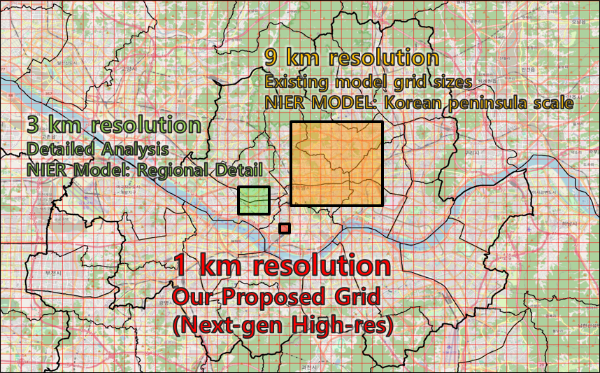
This is the first post in our build log for EnvDataLab.
We are building a national-scale, 1km air quality forecasting engine for Korea. The data collection pipeline and preprocessing are complete, and model training is the next milestone. Before sharing architecture details, this post explains why we are committing to fine-grid forecasting as a core product direction.
1) Problem Definition
Air quality risk is local, not abstract.
A single district can shift from moderate to harmful conditions within hours due to transport, topography, urban morphology, and boundary-layer dynamics. Yet many operational systems still rely on coarse grids or region-split workflows that are difficult to translate into neighborhood-level decisions.
For daily life, industrial planning, construction safety, and local policy execution, users do not ask for “national average PM.” They ask what will happen in their neighborhood and at the time window when action matters. This means spatial granularity, update cadence, and local consistency are product requirements.
At the same time, national-scale forecasting must be operationally sustainable. A system that is scientifically strong but too expensive or brittle to run continuously has limited real-world value. In practice, accuracy and operability must improve together.
2) Where Current Approaches Get Constrained
Current production stacks have delivered important value, but they also expose structural bottlenecks when the target is real-time, 1km national intelligence.
First, many workflows are tightly coupled to emissions inventory pipelines. This includes national and global inventories such as CAPSS, MEIC, EDGAR, REAS, and similar datasets used in regional systems.
The issue is not only update speed. A bigger operational issue is temporal allocation: annual emission totals are often split into hourly inputs using generic profiles. In real operations, that can miss abrupt local changes and weaken short-horizon forecast responsiveness, especially in high-resolution settings.
Second, coarse-grid cores and heavy HPC-oriented pipelines make high-frequency updates expensive. If each incremental improvement requires disproportionate compute overhead, scaling from research to always-on service becomes difficult.
Third, region-split logic can create boundary consistency issues. Air does not respect administrative partitions, and fragmented design can produce inconsistent confidence across neighboring areas.
These bottlenecks do not mean existing models are wrong. They mean a different design center is needed for the next stage: finer spatial intelligence, faster iteration, and stronger operational continuity.

Conceptual transition from coarse regional blocks to a continuous fine-grid intelligence layer.
3) Goal 1: Build a National 1km Forecasting Engine
Our first goal is straightforward: build a continuous national 1km forecasting layer that reflects local atmospheric reality more faithfully than coarse-grid products.
The purpose is not better visuals. The purpose is better decisions.
A 1km field can support localized risk windows, exposure-aware scheduling, and practical interventions where the difference between nearby zones is operationally meaningful. It also enables more credible comparison across regions because the same spatial logic is applied nationwide.
This goal sets a hard requirement: the model must preserve both macro transport context and micro-scale local behavior, including terrain and land-use effects.
4) Goal 2: Shift to a Real-Time, GPU-Operable Inference Stack
Our second goal is to make forecasting operationally lean: robust real-time inference on commodity or broadly accessible GPU infrastructure.
This is a product decision as much as a technical one. If inference can run reliably without extreme infrastructure assumptions, the system can update faster, recover faster, and scale more broadly. It also improves experimentation speed: architecture changes can be tested and validated without heavyweight operational cycles.
In short, we are not optimizing for a single benchmark run. We are optimizing for sustained, repeatable, service-grade forecasting.
5) Goal 3: Remove Emissions Inventory from Model Inputs
Our third goal is to reduce direct dependence on emissions inventory as a model input.
This is intentional.
In our architecture direction, the model learns from observation-grounded states and physically meaningful drivers: station observations, meteorological transport fields, global/coarse priors, static geographic constraints, and temporal conditioning. The focus shifts toward state reconstruction and transport-consistent evolution.
Why can this work?
Because the atmosphere already encodes the integrated result of emissions, chemistry, transport, and deposition at each observed state. A model anchored to observations and dynamic meteorology can learn the evolving field directly, especially when multi-source priors and autoregressive rollout are used with strong quality controls.
This does not reject physical reasoning. It reframes where physics enters the system: through transport-aware design, temporal conditioning, and consistency constraints, while reducing dependence on any single upstream inventory pipeline.
For clarity: this is not an anti-science shortcut. It is an engineering choice to improve high-resolution resilience under real operational constraints.
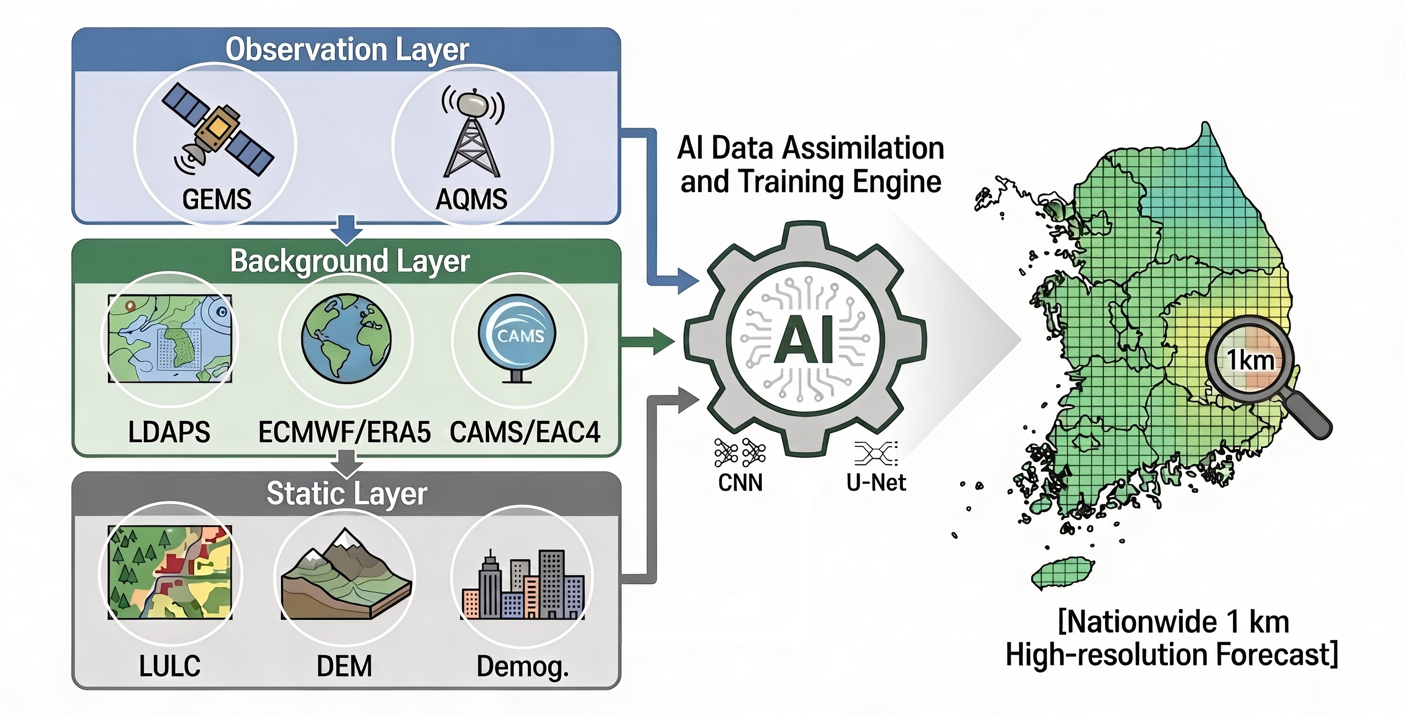
Observation, background, and static layers integrated into an AI assimilation engine for nationwide 1km forecasting.
6) Conclusion
EnvDataLab is choosing a direction that is both scientific and operational: national 1km granularity, real-time deployability, and observation-driven modeling that does not rely on direct inventory forcing.
This direction is not a final claim of superiority; it is a deliberate hypothesis with clear implementation goals and measurable outcomes. We have completed the data and preprocessing foundation.
The next posts will document the build sequence we can execute now: data stack details, architecture rationale, and training execution plan under limited compute.
If this hypothesis holds, the outcome is not only a better map. It is a more actionable air intelligence layer for real decisions in the places where people actually live and work.